
Keyword
Earth Science | Biological Classification | Animals/Vertebrates | Mammals | Cetaceans
6 record(s)
Type of resources
Topics
Keywords
Contact for the resource
Provided by
Formats
Representation types
Update frequencies
Status
draft
-
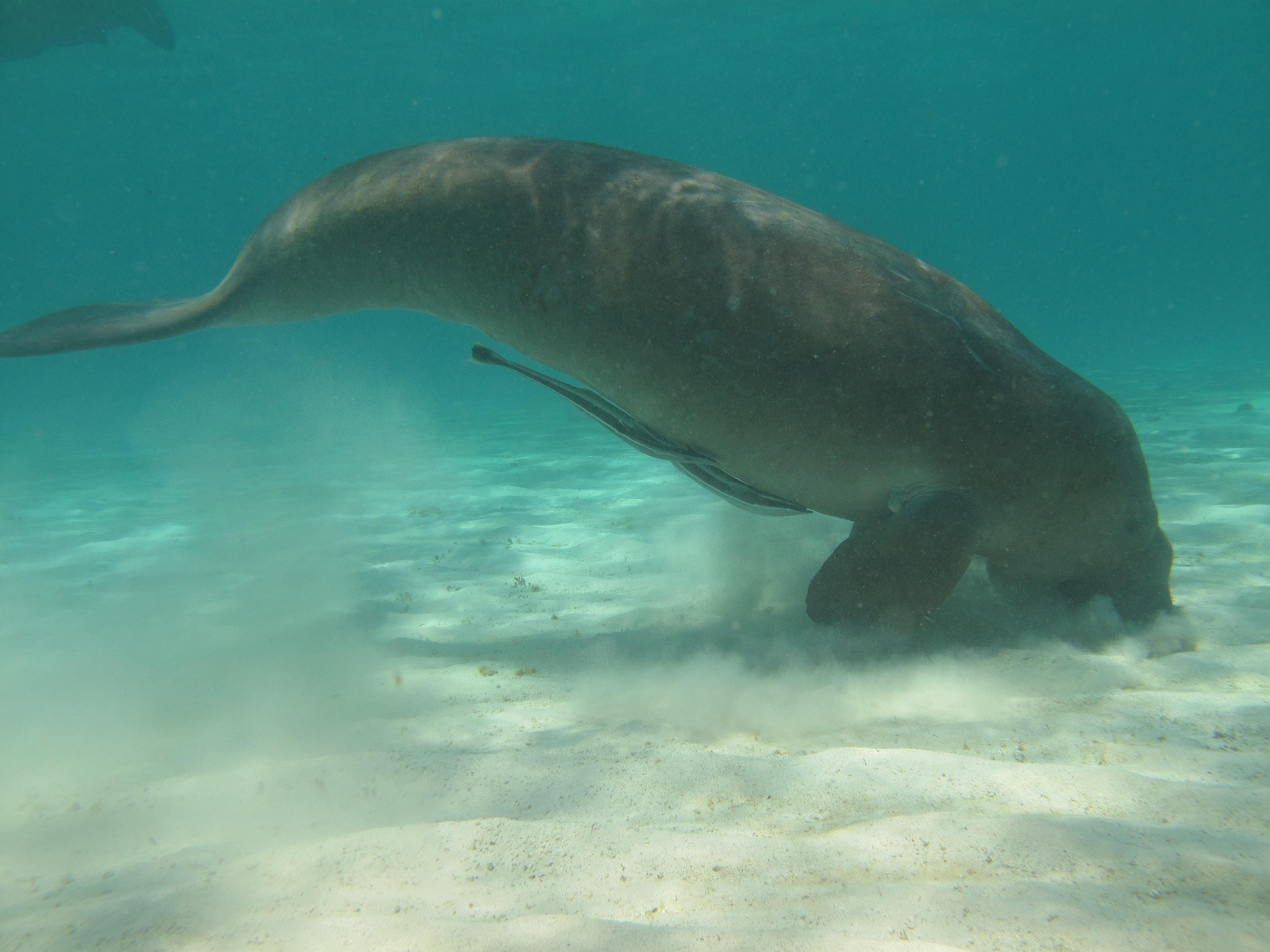
Dugongs (Dugong dugon) are listed as vulnerable on the IUCN Red List of Threatened species and as other specially protected fauna in WA under Schedule 7 of the Wildlife Conservation (Specially Protected Fauna) Notice 2015). Gaps in our knowledge in Western Australia include having a good understanding of the species’ distribution, abundance and high use areas across the northwest. This 3-year project (2014-2017) integrated Indigenous knowledge and scientific observations from field surveys to better understand the distribution, abundance and movements of dugong in the Kimberley region. The data collected also provides a baseline for future monitoring and management. This medata record relates to raw and processed aerial survey data of marine fauna collected between 21st September 2015 and 8th October 2015 in Kimberley coastal waters to the 20m bathymetry line, comprising dugongs (Dugong dugon), Australian snubfin dolphins (Orcaella heinsohni), other dolphins (bottlenose, spinners, false killer whales), humpback whales (Megaptera novaeangliae) and large, mostly green turtles (Chelonia mydas). The WA Department of Biodiversity Conservation and Attractions (DBCA, ex-DPaW) and CSIRO provided additional resources to extend the North Kimberley dugong aerial survey boundary westwards (Broome to just past Port Hedland) to cover the South Kimberley-Pilbara coastal regions, to close the last remaining knowledge gap of the dugong distribution and abundance in Australia. This additional survey was completed in May 2017. Data from a trial movement study undertaken between 1-18th August 2016 also forms part of this metadata record. Five dugongs were tagged with Telonics manatee/dugong tags. GPS and ARGOS satellite detection locations and dive data were downloaded weekly from the ARGOS web site.
-
The aim of this study, as part of a large number of related studies, was to examine the occurrence of cetaceans and seabirds along the 110◦E meridian from temperate to tropical waters (39.5–11.5◦S). Cetaceans and seabirds were actively scanned for across a four-week period spanning austral autumn to winter. Acoustic recordings of vocalising cetaceans weremade using directional and omnidirectional sonobuoys (n = 87 deployments). In total, seven cetacean sightings (six baleen whale, one toothed whale), 186 seabird sightings and 225 cetacean acoustic detections were recorded. A total of 22 seabird species were sighted, including, petrels, albatrosses, tropicbirds, terns, shearwaters, boobies, frigatebirds, gannets, gulls, skuas and prions.
-
This record is an overview entry for biological data collected on Soela cruise SO 3/84. This cruise took place in Tasmanian waters and the Bass Strait during 14 June - 12 July 1984, under the leadership of T. Kenchington and Brian Griffiths. Biological data collected on this cruise include demersal and mesopelagic fish samples from trawling. Blue grenadier samples from the west coast of Tasmania (fish more than 60 cm length of this species seemed close to spawning). Stomachs, gonads, tissue samples for electrophoresis and fish for morphometric analysis. Large quantities of zooplankton samples, particularly euphausids. Acoustic data to aid development of a potential recording system for the scattering layers. Length-frequency data obtained by subsampling. Blood smears from a variety of fish species (for Plymouth Polytechnic). Biological data from a wide variety of sharks. Cephalopod, crustacean and other invertebrate samples for identification and further study (Victoria Museum). Samples of Lampanyctodes for oil content analysis (University of Tasmania and CSIRO Division of Food Research). Observations on seabirds, and on approximately 30 humpback whales and 3 killer whales.(derived from the cruise report) - Biological Field Data Sheets recorded during this voyage have been scanned to PDF, and are available (to CSIRO Staff) on-line. See the details link under "Stored Media List" (below).
-
This record is an overview entry for biological data collected on Southern Surveyor cruise SS 04/91. This cruise took place in the North West Shelf during 12-30 September 1991, under the leadership of Wade Whitelaw. Biological data collected on this cruise include demersal fish and invertebrate samples from 105 stations, with up to 70 species being caught per 30 min trawl. Greatest diversity occurred at the shallower stations. Length frequency data for 14 species of fish (see taxonomy keywords) and otoliths for 4 of the main species (L. choerorynchus, S. undosquamis, N. furcosus and L. sebae) were collected. Numerous fish specimens were retained for further taxonomic identification and stock discrimination studies. Live berried scampi samples were obtained from 3 scampi trawls for larval rearing studies (UWA). 35 mm camera photography of 63 trawls including video photography of the last trawl to study the effects of the trawl on the benthos were obtained. Numerous whale sightings were also observed during the cruise and 3 hydrographic transects were completed with the submersible data logger (SDL). Please note: This metadata record is a preliminary entry derived from information in the cruise plan and/or cruise report. Individual data types - which may span several cruises - will be indexed separately within this metadata system in due course. - Biological Field Data Sheets recorded during this voyage have been scanned to PDF, and are available (to CSIRO Staff) on-line. See the details link under "Stored Media List" (below).
-
This record is an overview entry for biological data collected on Southern Surveyor cruise SS 07/97. This cruise took place in the North West Shelf during 7 August - 1 September 1997, under the leadership of A. Whitelaw. Biological data collected on this cruise include numerous demersal fish and invertebrate samples; length-frequency data for 14 species of fish, and numerous otolith samples from four major species; additional fish specimens from two deeper water trawls (east of the Rowley Shoals), at 310 m and 105 m; photographs of fish and invertebrates for taxonomic studies and the "Handbook of Australian Seafood"; SDL (submersible data logger) data from 3 hydrographic transects and 35mm photography of 50% of the random trawl stations were obtained. 184 humpback whales, 24 unidentified cetaceans and about 175 dolphins were observed by Environment Australia personnel. Please note: This metadata record is a preliminary entry derived from information in the cruise plan and/or cruise report. Individual data types - which may span several cruises - will be indexed separately within this metadata system in due course.
-
The Interim Register of Marine and Nonmarine Genera (IRMNG) is a provisional (or ‘interim’) compilation of genus names – including species names in many cases – and covers both living and extinct biota into a single system to support taxonomic and other queries dealing with e.g. homonyms, authorities, parent-child relationships, spelling variations and distinctions between marine and non-marine or fossil and recent taxa. Taxonomic names in IRMNG are assigned flags to distinguish between marine vs. non-marine, and extant vs. fossil status; they are also arranged into a simple management hierarchy for navigation purposes, compilation of statistics per taxonomic group and more. Fuzzy matching is also supported (using "Taxamatch") so that a misspelled name can in most instances be reconciled to a correctly spelled name at genus or species rank, where this is held. IRMNG was a project of OBIS Australia designed to assist in the provision of marine species data to OBIS, by permitting the discrimination of marine from nonmarine (and extant from fossil) species records on the basis of the genus name portion of their scientific name (normally, genus + species, or genus + species + infraspecies if applicable). The aim of the project is to (a) assemble as complete a list as possible of the estimated 150,000 extant and 50,000 fossil generic names in current use, plus their possible further 250,000-300,000 synonyms, and (b) flag as many of these as is possible with their marine/nonmarine, and extant/fossil, status. Relevant species lists are also being attached to the "correct" instances of genus names as available. IRMNG was developed and based at CSIRO, Australia from 2006-2014, and from 2016 onwards it is now hosted at VLIZ, Belgium: http://www.irmng.org/